Delnies
This week saw the arrival of planning application 23/04419/MSC for ‘Approval of Matters Specified in Conditions 1 (Phasing Plan) and 2a (Area Development Brief) of Planning Permission in Principle Ref: 20/00599/S42 | Land To North Of A96 Extending From Whiteness Access Road To The Common Good Land Nairn’.
This relates to the agricultural land which was recently up for sale on the north side of the A96 just west of Nairn and it goes back to planning application 08/00080/OUTNA first submitted in 2008 for a ‘Mixed use development of 300 houses; tourism and heritage, equestrian and ecological centres; hotel and conference facilities; championship golf course, clubhouse and golf academy; community woodland and country park with associated infrastructure’.
So what does this mean? Well to get the whole story go to the ‘Documents’ tab of the current application and take a look at the ‘DELNIES PHASING PLAN’ and then the ‘DELNIES PHASE 1 AREA DEVELOPMENT BRIEF’. There’s a lot to read and digest here but here’s a very brief overview based on my first reading of it.
The first document lays out the whole scheme, as summarised on this map:
The development will be in phases and done in order:
Phase 1 housing in the pink area
Phase 2A a country park and community woodland in the orange area
Phase 2B a tourism and heritage centre in the green area with “infrastructure planting”
Phase 2C a gold course, clubhouse, golf academy, and hotel in the yellow area
Phase 2D golf course expansion and an equestrian centre in the blue area
If you were in the ward in 2008 you may have some memory of this original application but this will be new to many of you.
What this new application about is Phase 1. The area of land it will use has changed slightly from the original application for some reason and there’s a bite out of the north west corner compared to the original rectangular site but the essence of it remains, as shown on this map from the second document.
What is being proposed is a 300 home residential development to the west of the Sandown land owned by Nairn Common Good. It would be accessed from a new roundabout on the A96 and could incorporate a new primary school if Highland Council chooses to build one there within twenty years, otherwise the land remains with the developer (see application 20/01573/S75M).
It includes a village green, a small commercial hub and a bus terminal. The development proposes “a connection to the existing public drainage network in the northeast” i.e. it will use Nairn’s existing sewage system.
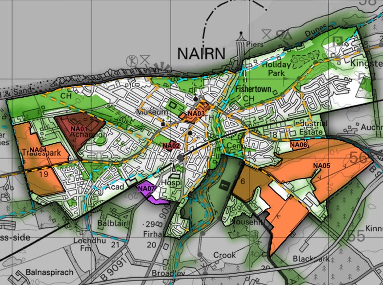
If you’re wondering how this fits into the emerging Inner Moray Firth Local Development Plan, about which I’ve written here many times, it doesn’t. This is the map for that Plan and only the orange areas are zoned for housing.
This development lies immediately to the west of NA04 so is not zoned for housing in the new Plan however it was in the old adopted Plan, which it was in as zone NA6, and it’s on that which the developers are relying as the new plan is still not adopted.
There are all sorts of issues with this application which I’m sure will attract comment from both individuals and organisations around the ward.
In planning matters, if a councillor makes comment to either support or object to a proposal before it comes to committee, then such comments would rule them out of participating in any vote, as applications are supposed to be judged on their merits given the full presentation at the relevant committee hearing so I’m not able to comment on this application myself beyond describing it, as I hope I’ve done above but if you want to comment, you should do so, either via the web site or by emailing eplanning@highland.gov.uk


